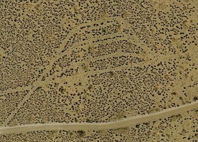
38.160790, -110.611115
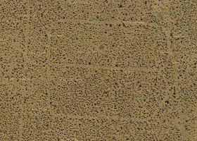
38.134322, -110.598694

38.324733, -110.550246
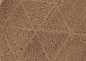
38.546624, -110.115218
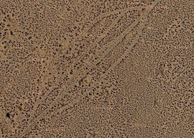
38.164847, -110.577647
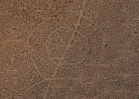
38.650236, -110.236100
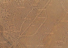
38.413210, -110.380883

38.479706, -110.035876
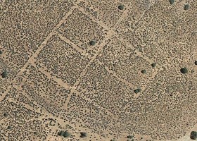
38.450752, -109.552140
The upper satellite photographs show some examples of the mysterious signs in the desert flats southeast of Hanksville / Utah. The names have no special meaning - I use them only for sorting reasons. They have diameters of around 200 meters! Most of the symbols I found so far are marked in a Google map... more than 1000 items! It is clear that there exist many more of such markers and the maps not include all of them. If you find similar symbols, which are not in the map, feel free to email me the coordinates.
I found them during my preparations of our trip through Utah in April 2014. Also, I marked some interconnecting lines where normally only one type of the symbols appear. They are mostly very straight over tens of miles. Such lines exist everywhere in the southwest, even in Mexico, but most of them without symbols. All those landmarks and lines must have a technical background, for example old agriculture remains, prospecting methods or military reasons. Some of them (especially the ones near Hanksville, UT) seem to be at least decades of years old, as they are partially covered with sand dunes.
After a research in the internet, I found out that people found these symbols first in 2009, when Googles satellite maps began to have a sufficient resolution. Maybe, Ed Payne from Lindon, Utah was the first who has made these amazing discoveries using Google Earth [1]. I read some controversal discussions from that time, but no one came to a final conclusion, what was found here. This is why I made a closer examination.
First I was thinking about the native indians, as the symbols remember to all the petroglyphs, which are engraved in many places in the area. The indians used stones or removal of stones, to produce long durable ground patterns. But those here are made by removal of vegetation only. Also, they are too large, too precise, too many of them to be made by a handful of indians living in the area before. Thus, the reason has to be technical and not older than around 100 years. Vegation is still not completely back in the lines and sand covers only some parts of it. In a closer look, one often see, that the straight lines are made of two parallel lines with sagebush in the middle - meaning they were made by machines with tires or ropes.
To find out, what made such patterns on the ground, I started a research in the web and tried to find similar patterns elsewhere. First, I checked, if the patterns are remains of an old indian culture (sure, it is a nice idea to find "nasca-lines" elsewhere). Also, a military operation was maybe the reason. Or, ore and mineral prospection produced such removal of vegetation. This most propable reason, I found also in a reseach of a german museum from 2010: "Excursus: Nazca in Utah?"[2].
Before the planned trip, I wrote e-mail to an archeologist from BLM office in Moab . He found my report interesting and answered the following:
..."Those are some very interesting images, thanks for sharing. Feel free to contact me, if you'd like to visit with us during your visit.
We'd be interested in hearing your perspective on what you've found...."
Then I tried several times again to make an appointment by e-mail, but never got an second answer.
The day we were in Moab, I visited the BLM office, but the guy at the entrance did not allow us to go in (officialy, none of the archeologist was in house).
He gave me an internal phone, that I was able to left a message and my phone number on the mailbox of the archeologist I've contacted before. I never got any answer.
Before, we visited the famous 'wave' (we were lucky to win the 'walk-in lottery' in BLM office in Kanab), and I told one BLM officer about the signs.
She was very interested, and after some weeks I got an e-mail of her with statements of her and her colleagues about the symbols in the desert ground:
".....I followed up with a couple BLM archaeologists about the geoglyphs you saw on Google Earth, and neither of them knew exactly when they were formed or by whom, but they said it would be alright if I passed some of their speculations on to you.
Here are comments from the archaeologist who works for the Grand Staircase-Escalante National Monument:
I've talked with some geology folks, and they're sure the straight lines are from seismic exploration, but nobody has a clue why the circles, spoked wheels, and the "flower" are there.
I'm thinking some kind of experimental seismic technique that never made the big time.
One thing for sure, they're not ancient Indian "geoglyphs," unfortunately!
A review of historic aerial photos of the area would pin down when they were made, I'm betting 1950s or 1960s.
The BLM Hanksville archaeologist went out there years ago and photo'd some of them; down at ground level you can see they are tractor-made but not used extensively for anything.
The archaeologist who works for the Richfield Field Office area responded with this:
I am aware of some of these odd "geoglyphs" on Google Earth and Arcmap, but they are actually vegetation circles.
[The Hanksville archaeologist] first showed them to me in Google Earth and he went to investigate a couple of them some time ago.
He documented that they were created by removing vegetation in patterns.
I'm not really sure what or who created them, but they can't be too terribly old because they are created by the removal sagebrush and other vegetation.
I would guess by bulldozer or some other machine, but most are far from any roads. Most are associated with some other straight lines cut through the vegetation.
[The Hanksville archaeologist] guessed that maybe they were created in the recent past to help guide airplanes in the area, maybe uranium exploration?
Anyway, thanks for the puzzle!....."
Alright, now we had already some hints, but all of them were not sure about the orign anyway. On the other hand, it underpins my suggestions.
I found in an old Yahoo-Group (Oct 26, 2009) [3] the following statement:
"...The Utah Antiquities Section has been contacted on a number of occasions over the past year regarding strange patterns people have noted on the surface of the earth in remote areas of Utah.
The availability of Google Earth and increasingly better imagery have enabled people to make observations that were previously not possible.
In addition to receiving phone calls and emails (from all over the U.S., Europe, and South America), we have become aware of a number of web sites that draw attention to these 'geoglyphs'.
We have provided some information about the origins of these anomalies on our website...."
But if you follow the provided link, you land on an error page....
Anyway, we visited and examined the area, made photos and remarked some things.
Before we left Hanksville, we had a last stop at a fancy gas station called 'Hollow Mountain'.
The cashier weared a large gun on his belt and when he remarks that I was starring on it, he just said: "I am american"...
Ok, we decided to leave the place directly and headed south on US95 direction Hite.
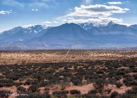
On the way to the 'flower' on the unpaved, sandy road (15 miles south of Hanksville, 4WD HC recommended), which is going further to 'Burr-Point',
we already saw the first lines
(photo)
cutting the landscape.
They are hard to find, when not looking along them
(photo), as the terrain is more or less flat.
They are remarkably straight and made by heavy machines, as the ground is partially depressed (even on stone).
Cows graze isolated in the desert around the symbols.
But it seems, that the cows use the connecting lines to move from one place to another
(photo)
.
An astonishing fact is, that they exactly know which lines to use or not, to reach e.g. a feeding place or water reservoir
(photo)
.
We found no human footsteps, only trails from cows. It seems that the cows prefer to run inside the lines as it is much easier to walk.
(We did the same, as outside the lines thorny plants and cactuses grow).
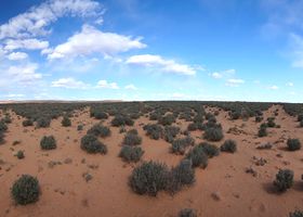
Finding the center of the 'flower' was not easy.
The sign is so big, that it is impossible to see all of it in the same time.
Only by using our GPS we found it finally (photo).
The symbol has 12 lines outgoing from the center. By defining 12 o'clock as the direction north, the lines in the photo can be indentified.
We walked along the symbol and we think, that the use for ceremonical reasons makes no sense.
It was a marker for aircrafts, or, a rope / cable (or similar) were lying here on the ground as a detector.
Until now, I did not find reports about such a technique, but I've read about inductive coils for ore prospecting.
Also, rarely, aircrafts installed with a second detector were involved in prospecting minerals, ore and oil.
Please refer the other orign possibilties above for more information about such techniques.
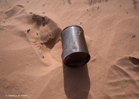
Allover in the area we found metal parts from machines and a lot of cans in different sizes
(gallery)
I'd wished to have a Geiger-counter with me... who knows what was happend here?
After the inspection of the desert it looks like a minig zone. The rusted oil can has the printing UAE 30 HD. An motor oil wich is used also for drilling machines.
We found a drilling hole which is at the end of a line inside solid rock. Something was fixed here
(gallery)
.
The line was strongly used, as one can see by the eroded rock and the still very good visible line in the sagebush vegetation.
But I did not find any official report about such activities. Maybe secret, not recorded or only forgotten.
Three different origins are supposable (Click for view article):
1. Ceremonical pathways from the native indians
2. US Army activities
3. Geophysical explorations, mining and prospecting in the uranium boom time around the 1950s
[1] "Ancient Landscape Lines and Geoglyphs, Utah", googleearthanomalies.com, 2010
[2] "Perspectives in the Pampa: ancient american huge ground drawings in Peru's desert", Museum Albersdorf, Germany 2010
[3] "Utah Geoglyphs - What They Are", Yahoo-Group (Oct 26, 2009)