The sympols are connected to very long and almost straight lines running through the desert.
Most of the symbols itself allow to walk into them and out again in a certain loop.
Often, the symbols have their own line and direction connecting them and were maybe markers for the ancient pathways.
Maybe, they were ceremonial procession paths and interconnections between different families of indians living there before.
It is remarkable, that special symbols are concentrated in certain areas. Maybe they are clan-symbols of groups living in this area.
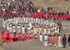
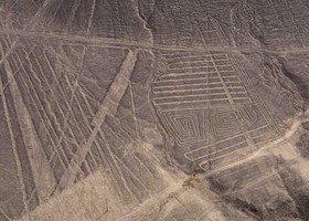
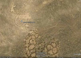
Here are photographs I found as a possible explanation for the circular signs.
The first shows a ceremony, which is still held from the native people in the mountains of south america.
Also, the lines and symbols remember strongly on the geoglyphs found in the andes in south america - the famous Nasca-Lines!
Also very astonishing is the fact, that different cultures all over the world formed similar and large geoglyphs like, for example, in the desert of Jordan.

The Incas celebrate a so called "Inti Raymi", which consist of various geometrical ceremonies and dances.
Inti Raymi is a nine-day winter solstice celebration worshiping an Incan god and involves colorful costumes, lavish banquets, festive music, and historical recreations.
It is a religious ceremony to honor the sun. The Incas also venerated huacas, or sacred objects, places, or people.
Huacas could be man-made or natural.
The mummies of dead rulers were considered to be especially sacred huacas.
Families would often have a sacred amulet or some other huaca in their home, which they sacrificed to in order to sustain the balance between nature and society.
I found circular, rectangular and other patterns, which have the same dimensions than the symbols found in Utah.

Prof. Anthony Aveni -- Water-Cult
Anthony Aveni compares the Nazca lines with the ceque-lines in Cuzco.
Those lines were made in connection with a calendar, water and mountain deities.
In this way, the Nazca Indians celebrated a water-cult ritual.
The figures and lines were used as paths for ceremonial dances.
Michael Coe -- Ceremonial Places:
Michael Coe also believes the Lines are sacred paths to walk during specific ceremonial rites.
But primary the lines was a offering for elders, heaven- and mountain-deities who spent water for fields.
Prof. Helaine Silverman -- Clan Signs
Helaine Silverman, the co-author of Anthony Aveni suggested that the figures are clan signs of different Indian tribes or families in the region of Nazca.
This idea is suppoted by the fact that many clans in North and South America often use an animal, or "totem," to represent their migrations in petroglyphs.
(Partially adapted from viewzone.com)

In the Harrat, one is able to find very similar geoglyphs and also petroglyphs.
The natural circumstances of this area remembers strongly on the landscape in Utah.
The volcanic loess ground serves to hold water and the stones prevent swift evaporation.
Thus vegetation not only occurs along the wadis, but can also appear in winter and spring among the stones, providing an unexpected pasture.
Petroglyphs of wild animals are abundant in the area along with riders on horses and camels and hunts of lions and hyenas.
This is the ecological and topographic background in which a characteristic set of archaeological features occur, known as "desert kites".
Due to its immense size it only became known to archaeologists, when the first regular postal flights from Baghdad to Cairo commenced in the 1920's.
Also circular paths were found. It is a strip of land, 1 to 1.5 m wide, cleared of rocks so that the underlying loess appears.
Sizes vary from 18 m to the largest yet measured of 106x90 m in diameter.
(Partially adapted from pasthorizonspr.com)
The area was populated by Anasazi (2000 B.C. to 1000 A.D.) and Fremont (600 A.D. to 1250 A.D.).
It is interesting, that most of the symbols can be also found in ancient petroglyphs on canyon walls in the same area.
The newspaper rock (Anasazi) is located in Canyonlands NP, near Blanding, Utah.
Not all of the symbols are understood. Beside animals and peoples, the rock is full of abstract signs. They can be signs for family clans or natural phenomena.
In Sego Canyon near Green River, Utah, one can find petroglyphs of various styles -
the fremont style looks different than the large symbols in the desert and thus, can not be the origin.
On the other hand, the symbols on Sky Rock near Bishop, California, made by the Paiute, remembers strongly on the found symbols.
Also, abstract symbols like spirals can be found all over the world in ancient civilizations [3],[4].
The landscape was not dry as it is now.
Thousand years ago, it was grassland which became more and more steppe before it was turning into a desert.
The ancient farming indians moved from the flats into the canyons to find water.
In this last period they built stonehouses in the rims at very protecting places.
It shows, that they were fighting each other for water and for the best places to survive.
The houses and clans became larger (better protection against other groups) while they moved toward the south.
Smaller houses can be found in canyons in Utah, while the larger houses were built later in New Mexico and Arizona (Mesa Verde, Canyon de Chelly, Chaco Canyon).
Then they disapeared finally. The reason is not clear, but it has something to do with the contact to the aggressive indians from Mexico, with upcoming cannibalism and also with the climate change in the area.
Maybe,the lines are still visible, because the grass was removed inside the paths and after, sand was filling up the paths by erosion.
Today, less vegation can be grown inside the paths, as there is less organic material left from the past.
Some of the lines show ways to water sources or passways into and through canyons to other flatlands.
It is remarkable how precise straight (over miles distance) most of ways are!
The idea, that indians from the past made all these symbols, is interesting, but PROBABLY WRONG. Ok, there are some similarities to other ancient geoglyphs in the world and also some geometrical symbols can be found also in petroglyphs, but circles, triangles, squares and lines are nothing very special. The precision and sizes of the symbols have, more probable, a technical reason. Animals and other signs can not be found in the Utah geoglyphs. After the inspection of the area and interviewing some archeologists (see page before), it must have a DIFFERENT ORIGIN.
References:
[1] Native American Indians
[2] Bureau of Land Management
[3] Spirals in Ancient Civilizations
[4] Comparision of spiral geoglyphs