During the late 40s and 50s of the last century, the cold war and the development of atomic weapons lead to an uranium minig boom in the southwest of USA.
Uranium was suddenly the most critical material the United States had ever known. It fueled atomic weapons.
It promised electrical power; gas-free operation of cars, planes, and locomotives; preservation of meat; and even distillation of sea water.
Most important, a domestic supply of uranium was needed to maintain a nuclear edge in the cold war that was developing with Russia. The U.S. uranium mining industry is relatively young.
It went through a brief golden age between about 1955 and 1980, beginning when the United States offered generous incentives to shore up its stockpiles of the nuclear weapons fuel during the Cold War.
In the early days, the government offered a 10-year price guarantee for certain kinds of uranium ore. It also paid out a $10,000 discovery and production bonus for each new source of supplies, which pencils out to roughly $95,000 in today's dollars.
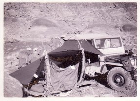
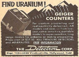
That set off a gold rush in the nation's vast Western region. Everyone with a jeep and a Geiger counter was out trying to get rich.
By the 1960s, the program had packed U.S. storehouses so full of uranium stockpiles that the government stopped paying the incentives.
However, it left in place rules barring the use of foreign uranium until 1975, when it began to allow a growing percentage of overseas supplies into the market.
Price declines in the late 1970s and early 1980s forced the closure of numerous mines.
Most uranium ore in the United States comes from deposits in sandstone, which tend to be of lower grade than those of Australia and Canada.
Because of the lower grade, many uranium deposits in the United States became uneconomic when the price of uranium declined sharply in the late 1970s.

Report from the 50s:
"We moved to Moab in 1955 - chasing the uranium dream with a brand new 1955 Dodge Power Wagon, pulling a 24' Boles Aero travel trailer and a 1951 Willys CJ3 with a little military jeep trailer.
We initially prospected in the Circle Cliffs area where my Mother discovered a small deposit of carnitite.
She was using a Geiger Counter or scintillator and watched the needle practically bend in two when it pegged out!"
In the Canyonlands National Park came up a controversy:
In 1959 C. J. Olsen recommended the acquisition of federal lands in the Needles district in order to create a state park that would permit the multiple uses of hunting, grazing, and mineral development.
Worried that the areas would be withdrawn by the National Park Service and closed to commercial development, Olsen asked US Sen. Wallace F. Bennett of Utah to push for state stewardship over the area.
Agreeing that multiple use was "essential to the welfare of the people of Utah and the West," Bennett promised to use his influence to block the establishment of a single-purpose national park.

Surface exploration:
The first uranium exploration was surface based and everyone with a Geiger counter was able to find, mostly low-grade, uranium ore.
Extremly high-grade ores (more than 10% U3O8) are deep and difficult to find.
Finding the rest required advances in deep-penetrating geophysics and geological models.
Airborne Geophysics:
Airborne geophysics has evolved to allow deeper imaging.
High-resolution magnetic and electromagnetic (EM) surveys can detect basement features where they coincide with graphitic zones, the major marker for uranium deposits.
High-resolution gravity can also identify favourable structural features in conductive zones, and seismic surveys are being used to image the unconformity and related structural features.
After a prospective geological setting has been identified using geophysics to outline faulting and favourable lithologies, the area can be sampled using geochemistry on a reconnaissance scale.
However, the use of geochemistry is limited by the fact that unconformity-related deposits have a small footprint and usually occur at significant depths.
Drill core can also be sampled using a collection of 1 - 4 cm wafers at the end of each row in a core box and compositing them over a regular interval of 10 metres or so.
This way, the average geochemical values for specific elements can be compared on a hole-to-hole basis to pinpoint areas of alteration.

Ground Geophysics:
Whereas ground EM surveys were once used routinely to follow-up airborne surveys with deeper penetration through the sandstone, they are now more often used to provide detailed assessments of targets of interest.
Drilling:
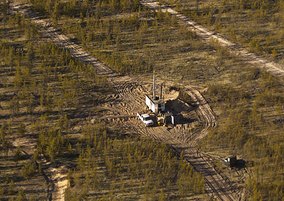
After targets have been identified by a combination of favourable geophysical and geochemical results, the next stage of exploration is core drilling.
Targets are drilled until a deposit is located or the anomaly has been explained.
Burgex Mining Consultants explain on their site the types of geophysical exploration methods in a very illustrative way.
Seismic Refraction methods or also used for findig water, gas and oil, which has also commercial interest in this remote area. I found reports, that show seismic exploration data from the area.
A seismic signal (explosion or heavy impact) is recorded by so called geophones. They are arranged in different arrays, which may caused the removal of vegetation in the desert near Hanksville.
That grazing, prospecting and mining is the origin of all those patterns in the area around and in canyonlands national park is the most reasonable idea. All facts together show, that such large area with all those eroded patterns are man-made by machines. It was allowed even to prospect in national parks. The technical view onto it, understroke that the "signs" are the remains of field measurement setups. Some of them are strange in a first view, but those are cutted always in 12 clock sectors, or 30 degree pieces of a full circle to determine directions, as described above.
References:
[1] Utah's Uranium Boom
[2] Uranium Rush Posters
[3] Map of Mining Claims in Utah
[4] geochemical survey layout
[5] Geological Survey Circular 217 - Uranium deposits in the White Canyon
[6] Burgex Mining Consultants